FAQ - Land Cover Changes
What is land use/land cover mapping?
Land use/land cover (LULC) mapping is the process by which land features are grouped into discrete categories for mapping purposes. Land use categories could include, for example, urban, agriculture, and mining, while land cover categories might include forest, woodland, grassland, and water. Land use/land cover categories can be very broad and general (such as those just described), very specific and detailed, or an intermediate level somewhere between the two extremes.
How is land use/land cover mapping performed?
There are multiple ways in which to map land use/land cover. The most common methods involve the use of aerial photography and/or satellite imagery, which fall under the subject of remote sensing (i.e. collecting information about Earth’s features without coming into direct contact with them). A technician can then delineate land use/land cover classes from the photographs or imagery, either manually (e.g. tracing the features) or through automated classification methods that look for spectral, textural, or other similarities in the photography or imagery.

Why is land use/land cover mapping important?
Land use/land cover mapping provide information to help land managers, scientist, policy makers, and others understand the current landscape. LULC maps and other data products are used for many purposes, such as global and regional monitoring studies, resource management, and planning. For instance, coastal managers may use LULC maps to monitor changes in coastlines resulting from severe storms, such as hurricanes, or human activity, while policy makers can use LULC data products to evaluate urban growth, model precipitation runoff, or to develop land use plans. Agriculturalist can use LULC data to plan irrigation and fertilization schedules, to evaluate past land use practices, or to quantify current and past land conditions.
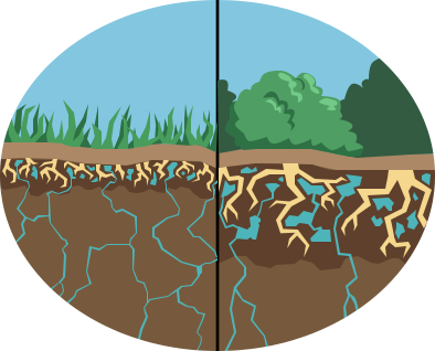
What is land use/land cover change (LULCC)?
Landscapes change over time. Agricultural fields may expand or contract, urbanization may encroach on former natural environments, and woody plant species, such as juniper, mesquite, and cholla might “invade” former grassland environments. In order to document and quantify these changes, researchers develop LULC maps from different time periods and then compare them. Through the process of land use/land cover change (LULCC) analysis, researchers and stakeholders can better quantify landscape dynamics overtime, predict future scenarios, and develop land management practices that consider past, present, and possible future conditions.

What are the benefits of LULCC analysis?
Land use/land cover change analysis not only documents the changes that have occurred on a landscape over time, it seeks to understand the mechanisms of these changes. For instance, what drives woody plant encroachment in former grassland environments? These changes could, for instance, be driven by overgrazing, land tenure policies, cyclical drought, or, even, a combination thereof. As land managers make complex decisions in a changing environment, an understanding of these various drivers of LULCC becomes paramount.
What is a small unmanned aerial system (sUAS)
The Federal Aviation Administration (FAA) defines an unmanned aircraft system (UAS) as an aircraft without a human pilot onboard, and all its associated elements, such communication links and components that control the aircraft. A small unmanned aerial system, as further defined by the FAA, is an UAS weighing less than 55 lbs but more than 0.55 lbs.
There are two primary classes of sUAS, fixed-winged and multirotor (rotary wing) copters. Fixed wing sUAS consist of rigid, stationary wings that generate lift. Multirotor copters typically consist of 2 (or more) rotary blades that revolve around a fixed mast (rotor).
How are sUAS used to map LULC and LULCC?
Unlike traditional remote sensing aircraft or satellites, sUAS are flown at low altitudes, usually at 400 ft. or below (in order to fly sUAS above 400 ft., pilots must have special permission from the FAA). Additionally, pilots have greater control of when and where sUAS missions are flown. While this gives land use managers greater flexibility in mission planning, the nature of sUAS limits the area that can be covered in a single flight (most off-the-shelf sUAS batteries only last about 30 minutes). Nonetheless, the spatial resolution (amount of detail) of low altitude sUAS photography/imagery is typically much higher than that achieved with traditional manned aircraft and satellite sensors. As a result, for more detailed LULC products can be derived from these product, albeit over a much smaller area. Additionally, the ability to pick when and where to fly enables land managers and producers to monitor change over time at the intervals most conducive for the needs of the managers and producers.
What is the output of a sUAS mission?
Different sensors are available for sUAS, from digital cameras and video recorders to multispectral sensors. For sUAS for LUCC mapping, photography and multispectral sensing are the optimal choices. Each sUAS flight, depending on area covered, will produce many individual images. For instance, a flight over a 10 acre area could easily produce hundreds of individual stills. Because the sUAS has an onboard GPS receiver, the photographs or imagers are “tagged” with coordinates (longitude and latitude). This enables advanced image processing software to properly place each image in relationship to the other images. The image processing software also geometrically corrects (orthorectifies) the images to ensure uniform scale throughout the final output image for measurements of distance and area. The final output of the sUAS image process is a seamless, orthorecitified image of the study area. This image can then be used for additional purposes, such as image classification for LULC.
Contact:
Dave DuBois
New Mexico State Climatologist
Department of Plant & Environmental Sciences
New Mexico State University
P.O. Box 30003 MSC 3Q
Las Cruces NM 88003
575-646-2974
Email: dwdubois@nmsu.edu